


Tour du Lac de Joux

drarep
User
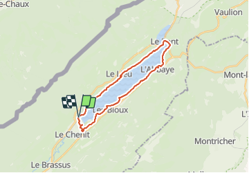

Length
24 km

Max alt
1099 m

Uphill gradient
269 m
Km-Effort
27 km

Min alt
1002 m

Downhill gradient
269 m
Boucle
Yes
Creation date :
2017-07-03 00:00:00.0
Updated on :
2017-07-03 00:00:00.0
--
Difficulty : Unknown

FREE GPS app for hiking
 SityTrail
IGN / Geographical institutes
SityTrail Plus
The world is yours!
About
Trail Walking of 24 km to be discovered at Vaud, District du Jura-Nord vaudois, Le Chenit. This trail is proposed by drarep.
Positioning
Country:
Switzerland
Region :
Vaud
Department/Province :
District du Jura-Nord vaudois
Municipality :
Le Chenit
Location:
Unknown
Start:(Dec)
Start:(UTM)
288721 ; 5166216 (32T) N.
Comments